
Mining & Trade News
Malawi Online News
Top Stories
Mining
DY6 PURSUES HIGH POTENTIAL COPPER MINERALISATION IN KARONGA
May 06, 2025 / Marcel Chimwala
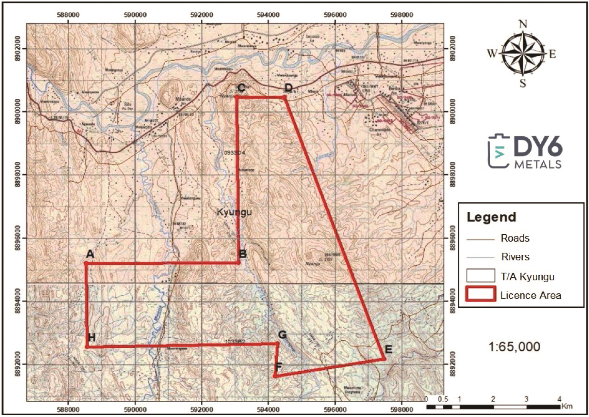
Topographical map of the Karonga licence EL0782/24
The Malawi Mining and Minerals Regulatory Authority has granted a prospecting licence to ASX-listed DY6 Metals for the Karonga tenement which covers a recently identified high potential Copper (Cu) mineralisation anomalous area.
DY6 Chairman Dan Smith says in a Press Statement that the licence grants to DY6 the exclusive right to prospect for copper, rare earth elements, lithium and other minerals for a term of three years with an option to renew for a period not exceeding two years.
Smith explains that preliminary reconnaissance/ surveillance sampling work on the licence area revealed occurrence of elevated Cu grades, with initial portable XRF results ranging from 1.4 to 7.8% Cu in rock with the results to be verified using standard laboratory-based XRF analytical assaying methods.
He states: “DY6 has recently acquired and completed reprocessing of historic hyperspectral survey data, which has been used to map areas with high probability for copper mineralisation. The results from this exercise correlate well to the mineralisation identified in the sampling work.”
“Historic anomalies from regional airborne geophysical radiometric and magnetic data appear to correlate with both the hyperspectral probability copper mineralisation mapping and the preliminary sampling reconnaissance work conducted.”
“Exploration for Cu and other minerals will continue on the licence area.”
The Karonga Prospecting Project is located about 440km north of the capital Lilongwe. It can easily be accessed using Karonga-Chitipa M1 Road turning to the west at Kasikisi School signpost along the M1 Road.
Geology and Mineralisation
The Karonga area is associated with a series of NW-SE and N-S trending ridges with metamorphic Basement complex rocks commonly identified as windows within the Karroo System which overlies the basement. The Karroo System units are typically sandstones with carbonaceous shale formations.
The eastern part of the licence area is overlain by several patches of Karoo sediments and Cretaceous to recent lacustrine sediments, the interrelations of which are complex due to unconformities and faulting. This area is part of the northern sub-province of the Malawi Province of the Mozambique belt, active between about 700-400 million years ago. The major lithological components are gneisses and intrusives of the Misuku Belt, representing the south-eastern extension of the Ubendian Mobile Belt of south-western Tanzania into Malawi.
On a more local scale, the licence area is comprised of a suite of quartzite rocks, pegmatitic rocks and amphibole gneisses that intrude into the basement gneissic rocks forming the wall rock of the project area. The lithologies have a general NW-SE trend and are dipping west / south-west at very steep angles ranging from 600 to 850.
The presence of base metals and other related metal mineralisation is evident in the pegmatitic rocks and quartz zone (quartzite) group. The quartzite unit has clear malachite and azurite coexisting with sulfide minerals indicating the presence of copper and other base metals.
Surveillance/Initial Reconnaissance Work Done
1. Surveillance Site Visit
Four samples were collected on a recent reconnaissance visit to the site. The visit targeted an anomaly which was identified using a combination of geology and aeromagnetic data.
The samples were collected on a mineralised quartzite zone, which displayed disseminated mineralisation of malachite and azurite with sulfides. These samples were analysed using an Olympus Avanta Portable XRF (pXRF) machine.
Results showed elevated Cu grades ranging from 1.4% to 7.8% Cu. These samples were collected on a 60cm thick zone of an exposed portion of a 40 – 50m long quartzite zone.
The samples will be sent to SGS Randfontein laboratory in South Africa for a standard XRF analytical procedure to verify the Cu grades and other minerals’ grades obtained from the pXRF.
Samples collected on surveillance site visit Cu analytical results (pXRF
| KARSO22 | 8898932 | 594735.6 | 557.49 | 1.4 |
| KARSO22B | 8898988 | 594714.62 | 572.51 | 6.1 |
| KARSO22C | 8898977 | 594714.15 | 581.93 | 7.5 |
| KARSO22D | 8898992 | 594715.84 | 576.97 | 7.8 |
2. Hyperspectral Data Analysis and Interpretation
Historical satellite imagery data has been acquired, re-processed and interpreted by an experienced spectral data analyst from Dirt Exploration. This is intended to assist with probability mapping of several minerals including Cu mineralisation.
The data is extracted by spectral unmixing of the Sentinel-2 VNIR (Visible & Near Infrared) and SWIR (Short Wave Infrared) satellite imagery. Sentinel-2 VNIR/SWIR imagery is the highest spatial resolution satellite imagery available with 10m resolution.
Using a geochemical exploration technique called Mobile Metal Ions (MMI) the extracted and unmixed spectral bands provide some diagnostic mineral responses in the regolith (overburden / outcrop rock material) above a buried mineral deposit.
In the case of Cu mineralisation, six end-members are anomalous over Cu occurrences: azurite, gypsum, illite, hypersthene, beryl and jarosite.
“The results of the spectral data analysis combined with the aeromagnetic data signatures and confirmed by the four geochemical samples analysed using the pXRF machine shows the potential of the Karonga licence area for copper mineralisation and possible occurrence of a copper deposit that requires to be investigated further,” says Smith.
He explains that further exploration work is currently planned to follow the anomalies identified in the surveillance activities, including geochemical analysis of the four collected samples at SGS Randfontein laboratory in South Africa to verify and validate the results obtained from the pXRF machine.
The planned activities at the site include detailed geological mapping of the licence area; and detailed geochemical sampling of surface outcrop rock chips, soils and where possible trenching to be considered.
“The outcome of the activities above will lead to target generation for a future drill program, which will in turn be used for mineral resource and reserve estimations,” Smith says.
Share this:
Leave a Comment
Comments
Mining & Trade Review News

Agribusiness News

Subscribe to Newsletter
Rehabilitation:
The establishment of a stable and self-sustaining ecosystem, but not necessarily the one that existed before mining began. In many cases, complete restoration may be impossible, but successful remediation, reclamation, and rehabilitation can result in the timely establishment of a functional ecosystem.
Archives
Remediation:
The cleanup of the contaminated area to safe levels by removing or isolating contaminants. At mine sites, remediation often consists of isolating contaminated material in pre-existing tailings storage facilities, capping tailings and waste rock stockpiles with clean topsoil, and collecting and treating any contaminated mine water if necessary.
Stackholders Logos


